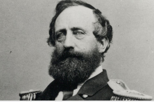
Henry Stellwagen, the first to chart Stellwagen Bank. Photo courtesy of NOAA.
By Seth Rolbein
Once upon a time there was a man named Henry Stellwagen.
Actually, we know when that time was, the mid-1800s, and we know that Henry served in the United States Navy and rose to the rank of lieutenant commander.
But that’s not why his name is still spoken by many people who fish, whale watch, or just like being on the water. The reason we pause to wonder about good old Henry Stellwagen is that a swath of nearby water is named after him; Stellwagen Bank.
Fishermen had long known about shallow grounds beyond the tip of Cape Cod, stretching roughly north and west toward Gloucester. Geologists will tell you that this arc from Provincetown to Gloucester was dry land thousands of years ago, when glaciers kept much of the ocean solid and sea level was much lower than in today’s warmer times.
Some called the area “Middle Ground,” perhaps because it was between land and the greater banks farther offshore, perhaps because it was between the Capes north and south, Ann and Cod. Like many places where the bottom rapidly rises, currents and upwells create a fertile mix, attracting fish from tiny to huge which in turn attract fishermen from across New England, including those on Cape Cod who can easily leave from Provincetown, for example, and make a good go of it in small boats.
But this place was not defined. Enter Henry Stellwagen.
In 1854, Stellwagen was on loan from the Navy to what was called the U.S. Coastal Survey. He was coasting on a steamer, and one reason why Stellwagen had been chosen to do this work was that he was ingenious; he had invented a new device that could “sound” the bottom, dropping to the floor to record depths by bringing up samples to prove they’d hit bottom, as well as offering a good idea of the terrain down there. He had fashioned a cup placed below the sounding lead with a valve of leather that acted like a little scoop — simple, but effective.
In October, Stellwagen, obviously excited, wrote to his temporary boss Alexander Bache, superintendent of the Coast Guard Survey, with big news:
“I consider I have made an important discovery in the location of a 15 fathom bank lying in a line between Cape Cod and Cape Ann – with 40 and 50 fathoms inside and to the northward of it and 35 fathoms just outside it. It is not on any chart I have been able to procure. We have traced nearly five miles in width and over six miles in length, it no doubt extending much further.”
His sounding invention offered up more details:
“The northern end of the bank has rocky bottom, with, however, a slight covering of fine black sand. The middle and southern parts are coarse white and yellow sand. The bottom inside of the bank in deep water is generally green unctuous mud, or ooze.”
Stellwagen was excited mainly because he realized his discovery’s importance for navigation in and out of teeming Boston Harbor. It would help “for a vessel bound in, particularly in thick weather, determining position with great accuracy … I consider the delineation of it as of more importance to the Mercantile world than the erection of a lighthouse.”
Bache got it, and in less than 48 hours sent a response:
“Do not leave Boston without receiving explicit instruction, except to determine this bank.”
Stellwagen charted an underwater plateau 19 miles north to south, six miles across at its widest southern point. Its depth below the surface is roughly 100 to 120 feet, much shallower than the waters around it that range to 600 feet. Earlier mariners suspected there might be two shoals out there, but Stellwagen confirmed it was one body.
In Bache’s 1854 annual report, he highlighted Stellwagen’s discovery “as an excellent mark for navigators entering this important bay. I propose to call this, from the name of its discoverer, Stellwagen’s Bank.”
One of the people who worked with Stellwagen was another inventive ocean mapper, Edward Cordell. Fifteen years later, he would chart another bank, similar in size to Stellwagen, on the West Coast. It became Cordell’s Bank, and the connection doesn’t end there; a century later both became National Marine Sanctuaries, designated by Congress for special protective status.
Stellwagen Bank National Marine Sanctuary came into being in October, 1992, 138 years after Henry sent down his sounding device. The word “sanctuary” seems a bit off; Stellwagen has been a busy commercial maritime thoroughfare and fishing grounds for centuries, far from pristine, almost urban by marine standards. Fishermen were nervous that the designation would lead to closures even though that option was specifically removed from the legislation. Thus far, commercial fishing continues on Stellwagen, while industrial exploitation like sand and gravel mining are off the table. Whales still congregate, helping create the lucrative whale watching industry.
Henry would have been proud.