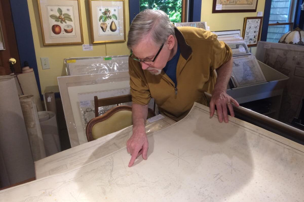
Bob Zaremba, of Maps of Antiquity, pores over one of George Eldridge’s homespun charts.
By Doreen Leggett
Two things happened around 1850 that had ripple effects which touch the lives of people drawn to the Cape’s waters today.
The first was that a talented fisherman by the name of George Eldridge fell out of the rigging of his coastal schooner in a gale and was seriously hurt.
The second was a storm tore open a new inlet in Nauset Beach in 1851, creating new shoals that were hazardous to mariners.
With fishing in his blood, Eldridge decided to become a chart maker and took to his dory to start mapping the coast.
“He knew where there were tricky waters and that better nautical charts would be a contribution to fishing families of Chatham,” said Bob Zaremba, who co-owns Maps of Antiquity in Chatham with his wife Danielle Jeanloz, and is well-versed in town lore.
Eldridge’s first map was titled “Chatham Lights to Southwest Part of Handkerchief” and it was an instant success.
“It was called the upside down map, because south is at the top,” said Zaremba of the chart that is now at the Atwood House Museum.
After his first map in 1851, Eldridge kept going. Several of his maps center around Stage Harbor because that is where most fishermen were heading out from.
Over time Eldridge became proficient at getting water depth, said Zaremba, his finger sliding over a copy of one of the Eldridge charts he has at his shop on Main Street. Eldridge used to take time to note the ocean floor as well; whether the bottom was sand or mud or rocks was all catalogued.
“If you are in the fog you can figure out where you are by taking a grab sample and checking the charts,” Zaremba said.
When Eldridge began his work, map-making was in its infancy in the U.S.. Thomas Jefferson – a Renaissance man of sorts – lobbied for a more formal process of mapping the United States and its waters. The colonies had been relying on England, but after the Revolution they couldn’t do that anymore.
The British Navy began its quality map-making in the mid-1700s, said Zaremba, and Jefferson began his efforts in the early 1800s. But it took almost 30 years for the federal government to get a map published to the level the British were at 50 years earlier.
Eldridge’s maps were quite different than those produced by the government. They gave intimate details of the waters off the Cape and ignored the land.
“He had a following because he wasn’t the federal government and he was quite folksy in his charts,” said Zaremba.
Eldridge was also an astute business man. He knew that legions of boats that sailed to and beyond New England would take cover during storms in a protected harbor on Martha’s Vineyard. So while vessels were holed up he sent his son, also George, around with an abundance of charts to sell.
During these days, maps weren’t one dimensional and dull. They were accompanied by books, or pilots, that taught certain skills – such as knot tying – and served as a compendium of useful knowledge for the mariner.
Eldridge’s first pilot, “Eldridge’s Pilot for Vineyard Sound and Monomoy Shoals,” was published in 1854 and had 32 pages, many noting local perils. This grey-bound book was the precursor of the Tide and Pilot Book, which followed 21 years later, according to the Eldridge’s family history.
Zaremba said he may be veering into legend, but it has been said that when George Jr. rowed around to the various schooners to sell his father’s charts he was often asked about the currents and tides in various spots. And sometimes he didn’t know the answer, so he hit upon the idea of creating a tide chart.
While the story may be historical fiction, tide charts have been a reality for close to 150 years. They have also been continuously in the hands of those who enjoy and work the water for a living.
“It is a serious resource — if you are a clammer in Chatham you probably own an Eldridge Tide Chart,” said Zaremba.